We use cookies to make your experience of our websites better. By using and further navigating this website you accept this. Detailed information about the use of cookies on this website is available by clicking on more information.
Developed by the Periplus team of subsea data experts, GRIDit is purpose built for the unique challenges of the subsea environment. Deployed on the Microsoft Azure cloud, it delivers a secure, scalable platform for managing subsea data.
In addition to providing a single source of truth for subsea data, GRIDit’s intuitive analytical tools unlock risk-based surveying, provide early warning of emerging risks, and underpin effective maintenance planning. Tools include:
These tools unlock the full value of subsea data, helping to save survey costs while embedding risk management into everyday operations.
Our online data storage platform brings together both public and private subsea data, providing a centralized location for conducting analyses, visualizing information, and generating reports.
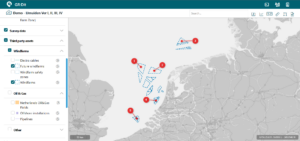
Say goodbye to time-consuming searches for accurate data. With GRIDit, offshore businesses can securely access and – if desired – share geospatial (subsea) data within and outside their organization.
With a single source of truth, time series data can also be harnessed to analyse changes to asset status over time. Risks are reduced and efficiency improved.
By maintaining control over your structured and up-to-date data, you can make informed decisions based on the latest facts in an intuitive manner .
Our platform makes it easy to share and protect specific datasets, ensuring that your data remains secure while allowing you to collaborate with stakeholders both within and outside your organization.
“Periplus’ expertise in GIS and hydrography is valuable, especially given our operations on the German market, where precise geospatial data is essential. We appreciate Periplus’ technical proficiency and commitment, which contribute significantly to the successful management and operation of our offshore wind farms”
“Within our organisation, GRIDit is used as the central platform for all available survey data, starting with the development and construction phase through to the O&M phase. We would recommend GRIDit as a user-friendly tool where all available survey data is centralised and easily accessible to team members.”
“GRIDit offers a range of practical tools – such as 3D viewer and Burial Assessment functionality – which we use for our compliance reporting. Its user-friendly design enables colleagues, even without technical expertise, to easily search for distances, cable layouts, cable crossings and other relevant data.”
We use cookies to make your experience of our websites better. By using and further navigating this website you accept this. Detailed information about the use of cookies on this website is available by clicking on more information.